How long do you want to wait to know there is fire in the forest? Most of the times, when someone notice about the fire, it is too late because the fire has spread.
In the summer of 2007, there were more than 80 people died in Greece and 670,000 acres (2,711 km2) burned because of fires. The same year in California, 500,000 acres (2,027 km2) were devastated by the flames, causing at least 14 fatalities.
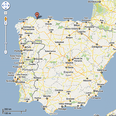
DIMAP-FactorLink, which under the name of SISVIA Vigilancia y Seguimiento Ambiental jointly commercialize projects for the environmental protection, have developed and integrated a forest fires detection system using the products of Libelium. The covered area is about 210 hectares in the North Spain region, comprising the Communities of Asturias and Galicia. The aim was to provide to different organizations of an environmental monitoring infrastructure, with capability to have alert management and to deliver early warning alarms.
The solution
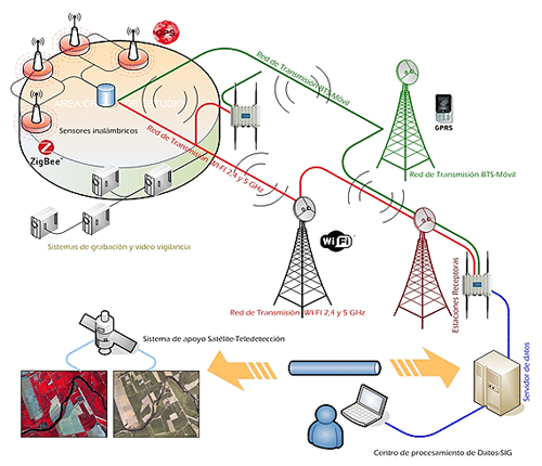
We can point out 3 main parts in the system:
-
the Wireless Sensor Network
-
the Communications Network
-
the Reception Center
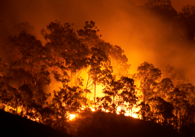
Apart from preventive measures, early detection of fires is the only way to minimize the damages and casualties.
Lets see a general diagram of the whole system here:
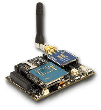
Waspmote OEM platform and Gases Board integrated in IOTSense platform
90 Waspmotes were deployed in strategic locations; 4 parameters are measured each 5 minutes:
-
Temperature
-
Relative humidity
-
Carbon monoxide (CO)
-
Carbon Dioxide (CO2)
These 4 sensors are connected to Waspmote through the Gases Board, which contains the electronics needed to implement an easy hardware integration of a lot of different gas sensors:
-
Carbon monoxide (CO)
-
Carbon Dioxide (CO2)
-
Molecular Oxygen (O2)
-
Methane (CH4)
-
Molecular Hydrogen (H2)
-
Ammonia (NH3)
-
Isobutane (C4H10)
-
Ethanol (CH3CH2OH)
-
Toluene (C6H5CH3)
-
Hydrogen Sulphide (H2S)
-
Nitrogen Dioxide (NO2)
-
Atmospheric pressure
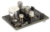
The amplification stage of each sensor is configurable to allow a better integration of the specific sensor. Moreover, this characteristic allows us to focus the accuracy of Waspmote in a region of interest. Besides, it is possible to control the power of each sensor separately, as their power supply lines are independent and can be controlled by Waspmote in real time.
Most of the sensors are affected by 3 parameters: relative humidity, atmospheric pressure and temperature, for this reason Libelium offers these sensors in the Gases Board, to minimize the error and get more accurate readings.
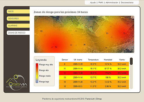
If some of these measured parameters goes above the configured threshold, then the system analyzes the information and reacts sending an alarm to the firefighters. They will know instantly that there is a fire and where it is with accuracy, because each Waspmote can integrate a GPS, that delivers accurate position and time information. The firefighters will be able to know where the fire is spreading with real-time information, which is important in order to know how the fire behaves.
In the video below can be watched the impact in the Spanish media about this deployment:
One of the main characteristics of Waspmote is its low power consumption:
- 9 mA, ON mode
- 62 μA, sleep mode
- 0,7 μA, hibernate mod
Waspmote is sleeping or hibernating most of the time, in order to save battery. After a predefined interval (programmed by the user), Waspmote wakes up, reads from the sensors, implements the wireless communication and goes back to the sleep mode. Each device is powered with rechargeable batteries and a solar panel, making the system completelly autonomous.
Libelium offers several wireless modules for the radio communication:
|
Model |
Protocol |
Frequency |
TX power |
Sensitivity |
Range* |
|
XBee-802.15.4 |
802.15.4 |
2.4 GHz |
1 mW |
-92 dB |
500 m |
|
XBee-802.15.4-Pro |
802.15.4 |
2.4 GHz |
63 mW |
-100 dBm |
7000 m |
|
XBee-ZigBee |
Zigbee-Pro |
2.4 GHz |
2 mW |
-96 dBm |
500 m |
|
XBee-ZigBee-Pro |
Zigbee-Pro |
2.4 GHz |
50 mW |
-102 dBm |
7000 m |
|
XBee-868 |
RF |
868 MHz |
315 mW |
-112 dBm |
40 km |
|
XBee-900 |
RF |
900 MHz |
50 mW |
-100 dBm |
10 km |
|
XBee-XSC |
RF |
900 MHz |
100 mW |
-106 dBm |
24 km
|
So we can reach up 40 km with Line of Sight (LOS) condition usin the 868MHz module. The high performance of Waspmote makes the readings really accurate and the transmission is highly reliable and flexible, placing the nodes at a mean separation of 1,5 km.
It is also possible to transmit the data via GPRS, as a secondary radio module for better availavility and redundancy in situations when it is critical to ensure the reception of the message, like possible fire alarms. The GPRS module is quadband (it supports any cellular connection provider), making it able to work all over the world, therefore this project we are describing is suitable for any country.
To help in the transmission of the data, 2 Meshliums were also installed, gathering the info and sending it via WiFi.
Meshlium is the only multiprotocol router in the world capable of interconnecting up to 6 technologies:
-
WSN: 802.15.4 / ZigBee
-
WiFi: 2.4GHz or 5GHz at high or low power
-
GPRS: quadband
-
Bluetooth: communication with cellular phones or PDAs
- GPS
-
Ethernet
Meshlium implements an easy connection between these 6 communication protocols. In this case, it gathers the info of the Waspmote ZigBee wireless network and sends it to the Control Center via WiFi.
Another application of Meshlium is using it to provide connection from a harsh environmet to entire cities. Meshlium is protected with an IP65 enclosure that allows it to work in outdoors conditions. Regarding to the power supply, it can be connected to a solar panel or to the lighter of a car, so that it can work without problems in the forests.
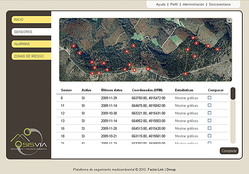
When the frames arrive to Meshlium, it parsers them dividing all the data in small pieces or variables that are stored in a MySQL Server Data Base. Once the data has been saved in the Data Base, then it is possible to manage it in the way we need. SISVIA created a Control Panel to show all the info with a graphic interface. The solution was integrated with a GIS (Geographic Information System), placing the data on helpful and nice 2D or 3D maps.
If you are interested in purchase information, please contact us.
References:
- Article from Libelium.com